Book here and get the best rate

The lowest price here

· Rate discounts
· Add points
· Exclusive benefits

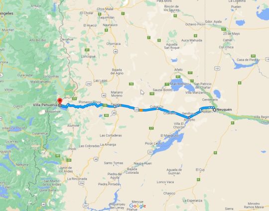
Villa Pehuenia is located in the province of Neuquén, 310 km from the capital city of Neuquén, in the direction of the Andes Mountains, bordering the Chilean city of Icalma.

GPS coordinates: -38.8796732 ; -71.1872083 - Google Maps 


IMPORTANT: In the winter it is essential to carry chains, because if ice or snow accumulates on the roads, only chains will allow you to drive safely. 

Please, get information about the road conditions before travelling from Zapala or Junín de los Andes by calling Vialidad Provincial at 0810-333-7882. Or also, to the reception of La Balconada by DOT Boutique at +541152633487. 

Or consult the following link: https://w2.dpvneuquen.gov.ar/ParteDiario.pdf which always shows the latest report from Vialidad Provincial. 

How to get to La Balconada by DOT Boutique?

In Villa Pehuenia follow Route Nº13 until you reach the commercial centre, turn left (if coming from Zapala or Aluminé - right if coming from Icalma), the petrol station will be on the left hand side. After 600 metres turn left and continue along the main road following the signs to La Balconada by DOT Boutique, at the next two forks keep to the right, when you see the parking sign for Posada La Escondida, take the only road that goes uphill to the left, pass the cattle guard and 100 metres further on you will find the entrance to La Balconada by DOT Boutique.


By car:

First of all you have to get to the locality of Zapala, province of Neuquén, and from there there there are 3 possible routes:

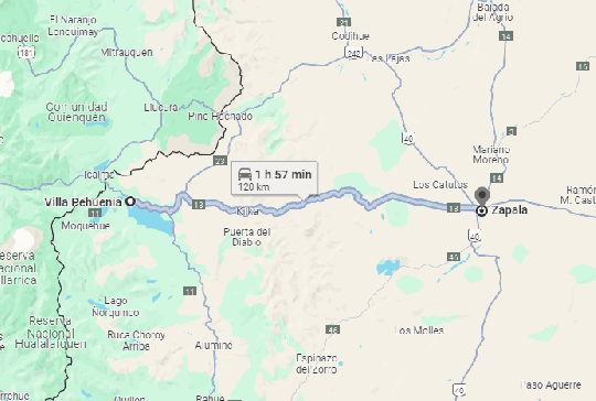
By Route 13: Called Primeros Pinos. There are 120 km in total of which 55 km are of Ripio. 

Route: at the exit of Zapala you will find a first roundabout, where you turn right as if you were going to Las Lajas, and after a few kilometres you will find a second roundabout where you turn left, which is Route 13 (there is a sign) to Pehuenia.

By Route 23: Called Pino Hachado. There are 155 km of which 35 km are of Ripio.

Route: at the exit of Zapala you will find a first roundabout, at this roundabout turn right as if you were going towards the town of Las Lajas and 6 km further on you will find on your left the road to the International Pass of Pino Hachado and about 500 metres before the pass you will find on your left the Route 23 to Pehuenia.

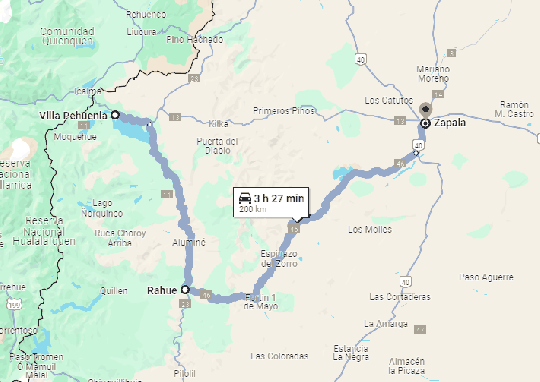
By Route 46: Called the Rahue. It is 210 km long, of which 50 km are of Ripio (in two sections).

Route: When you leave Zapala you will find a first roundabout where you turn left as if you were going to San Martín de los Andes. A few kilometres further on you will find Route 46 (the first route that appears) on your right, which passes through Laguna Blanca National Park, you will arrive at Aluminé and from there take Route 23 to Pehuenia.


By bus:

The only bus company that arrives to Pehuenia is Albus, which makes the route BsAs-Pehuenia, with transfer in Neuquén capital. The other option is to take Via Bariloche to Zapala and from there (distant 120Km.) take the same Albus or a private transfer.

By plane:

With respect to airports the most operative is Neuquén capital (distant 320 from Pehuenia since Zapala has no airport) and from there the same options as by bus (Albus or transfer to Pehuenia). Or the most practical, quickest and most independent option is to rent a car in Neuquén.

There is also the airport of San Martin de los Andes, Chapelco (215 Km. away from the village) and from there you can only get a private transfer or the bus service Campanados. In high season the company Albus usually offers a San Martín-Pehuenia service. Alternatively, you can rent a car.